
A “special” map
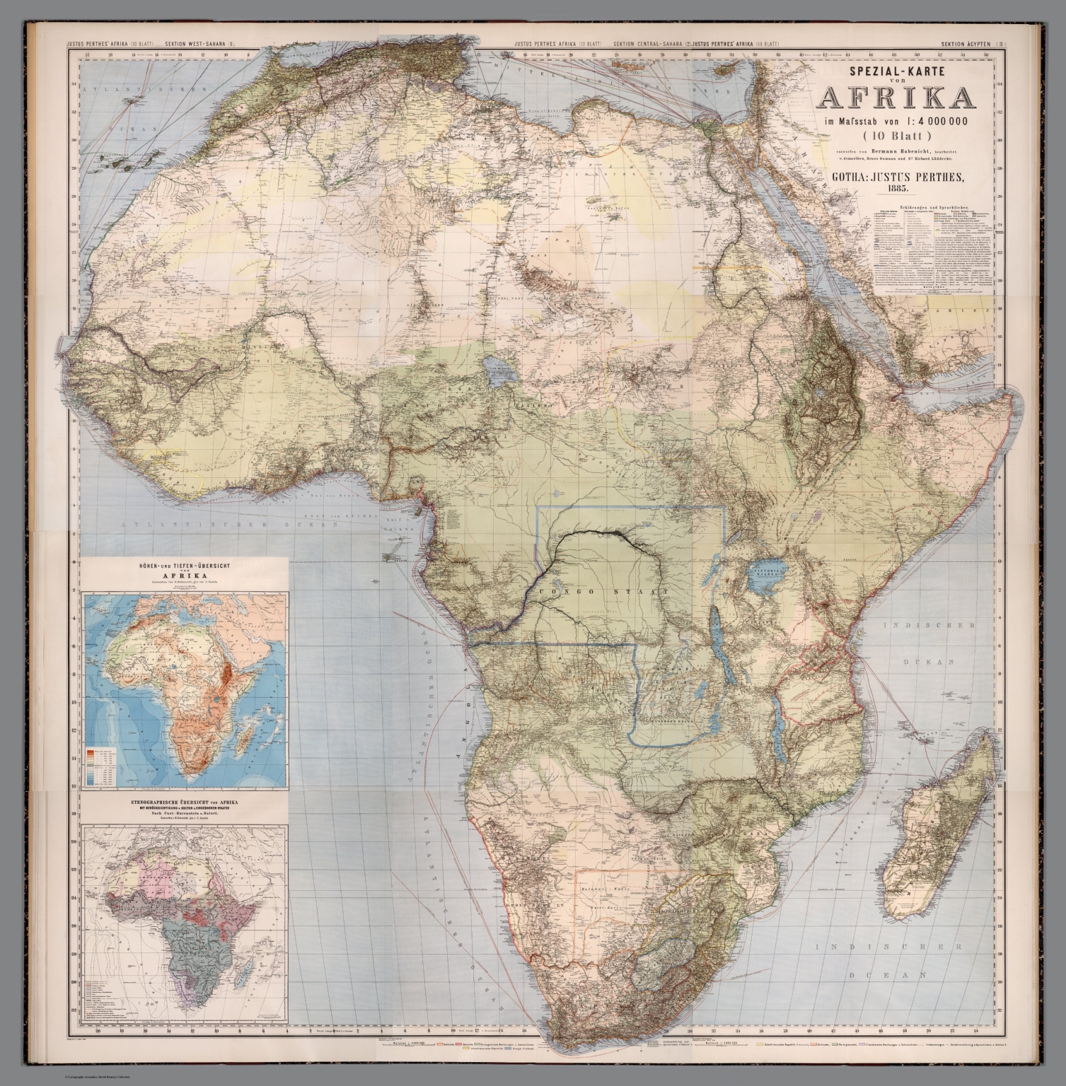
Composite map: Spezial-Karte von Afrika. Sheets 1-10 & Suppl. I-II. Gotha: Justus Perthes, 1885, https://www.davidrumsey.com/luna/servlet/detail/RUMSEY~8~1~317161~90086034:Composite-Map–Spezial-Karte-von-Af (accessed on November 12, 2024).
Before the 1850s, the African interior was largely an unknown land in Europe. The mystery surrounding the sources of the Nile, for instance, captivated the imaginations of Roman emperors, who organized expeditions during the 1st century CE. However, However, it was only with the spread of the travel accounts of David Livingstone, Richard Burton, John Hanning Speke, James Augustus Grant, Giovanni Miani, and others—whose reports filled European bulletins and magazines—that the territories around the equator began to intrigue the European public.
Allegedly, it was by reading the notes sent to The Times by Verney Lovett Cameron that King Leopold II of Belgium conceived the idea of organising the first Brussels Geographic Conference in 1876: the conference paved the way for the creation of the Belgian Congo, and, subsequently, for the so-called “Scramble for Africa”.
These explorations were driven by more than a simple thirst for “scientific” discovery. Expeditions required funding, and that funding followed the interests of capital. Journeys into the African interior offered opportunities to identify sources of commodities in high demand in Europe, such as ivory, gold, copper, and other minerals, while also opening new markets for European manufactured goods, including arms, beads, and cotton cloth. Maps like the one presented here were essential for disseminating the findings of these explorations and supporting the ongoing colonisation of Africa.
The Spezialkarte von Afrika (accessible here) was drawn by cartographer Herman Habenicht of the Justus Perthes’ Geographische Anstalt in Gotha, one of Europe’s leading publishers specialising in exploratory maps — a growing industry during the era of the Scramble. It is no coincidence that the first edition of this map was published in 1885, marking both the centenary of the publishing house and the Berlin Conference of 1884-1885.
Beyond its celebratory intent, this 210×200 cm map stands out for its remarkable detail and was explicitly designed as a tool for exploring and colonising the continent. Distinguishing between “explored” and “observed” areas, the map indicates not only existing caravan routes, telegraph lines and railway tracks are indicated, but also projected ones, along with details on river navigability, springs and the presence of wild animals. In creating the map, Habenicht and his two assisting cartographers, Bruno Domann and Richard Lüddecke, drew on the reports and observations from more than 500 travellers, some of whose routes are traced across the map’s 10 sheets, each measuring 49 x 62 cm.
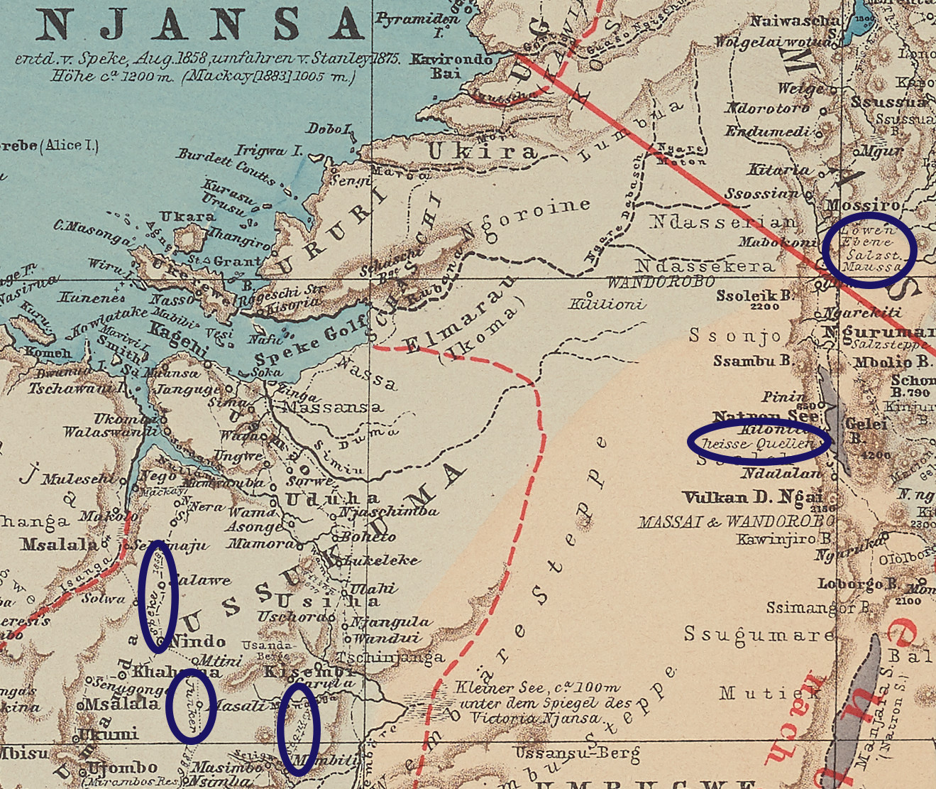
A portion of Sheet 8 of Habenicht’s Spezial-Karte von Afrika, including Lake Victoria. The circles in violet highlight information such as the presence of “Lions” or “hot springs” and the routes followed by John Hanning Speke, Wilhelm Junker and Henry Morton Stanley.
When critically analysed, the reports of travellers who crossed the African continent in the latter half of the nineteenth century provide valuable insights into commercial exchanges in East and Central Africa. This map, which visualises the routes of these travellers and identifies historical and now-superseded place names, serves as an important tool for our research. By mapping these routes and locations, we gain essential support for reconstructing patterns of African demand for goods such as arms, beads, and cloth in East and Central Africa.
References:
Pakenham, Thomas. The Scramble for Africa, 1876-1912. New York: Random House, 1991.
Bodenstein, Wulf. ‘Hermann Habenicht’s Spezialkarte von Afrika — A Unique Cartographic Record of African Exploration 1885–1892’. Terrae Incognitae 44, 2, 2012.